
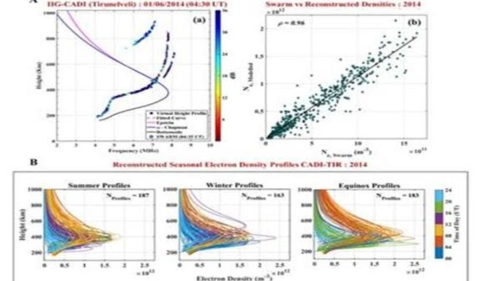

Researchers in India have developed a new technique to reconstruct the topside ionosphere over the Indian region for the first time by combining observations from ground-based and space-based instruments. The breakthrough is expected to significantly improve satellite operations, navigation accuracy, communication systems and space weather monitoring, particularly in the equatorial region where ionospheric behaviour is highly dynamic.
The research, carried out by scientists at the Indian Institute of Geomagnetism (IIG), an autonomous institute under the Department of Science and Technology (DST), offers a more accurate representation of the electron density in the upper ionosphere. The study, published in the AGU Radio Science journal, could also serve as a model for similar research in other parts of the world.
Understanding the Importance of the Ionosphere
The ionosphere is a layer of Earth’s upper atmosphere filled with electrically charged particles created by solar radiation. Extending from about 60 kilometres to over 1,000 kilometres above the Earth’s surface, it plays a crucial role in the transmission of radio signals and satellite communications.
Changes in electron density within this region directly affect the propagation of radio waves. High-frequency (HF) radio communications rely on the ionosphere to reflect signals over long distances, while satellite-based navigation systems such as GPS and India’s NavIC depend on stable ionospheric conditions for accurate positioning.
Any variation in electron density can introduce signal delays and positioning errors, making precise ionospheric modelling essential for modern communication and navigation infrastructure.
Challenge of Mapping the Topside Ionosphere
While scientists have developed reliable methods to study the lower portion of the ionosphere, known as the bottomside ionosphere, obtaining accurate information about the topside region has remained a major scientific challenge.
One of the key parameters used in modelling the topside ionosphere is the “scale height,” which describes how electron density decreases with altitude. Due to limited observational data, most existing models assume this parameter remains constant with height.
However, this simplified assumption often fails to capture the true behaviour of the topside ionosphere, especially over the Indian region where complex equatorial electrodynamics influence electron distribution.
These inaccuracies affect both scientific understanding and the operational performance of satellite-based technologies.
Combining Ground and Space Observations
To overcome these limitations, researchers developed a novel reconstruction technique by integrating data collected from two complementary sources.
The first dataset comes from ionosondes, ground-based instruments that measure electron density in the lower ionosphere. The second dataset uses radio occultation measurements from the COSMIC satellite mission, which provide valuable information about the upper ionosphere from space.
By combining these observations, scientists were able to determine how the topside scale height changes with altitude instead of assuming a fixed value. This resulted in a much more realistic reconstruction of the electron density profile extending up to nearly 1,000 kilometres.
The improved method provides region-specific estimates that are better suited to India’s unique ionospheric conditions.
Benefits for Satellite Operations and Navigation
The new modelling approach has important practical applications because most Low Earth Orbit (LEO) satellites operate within the altitude range covered by the reconstructed electron density profiles.
More accurate ionospheric information can improve satellite communication, navigation precision, space-based observations and mission planning.
The technique is also expected to enhance the performance of India’s NavIC navigation system alongside other Global Navigation Satellite Systems (GNSS), reducing positioning errors caused by ionospheric disturbances.
In addition, improved electron density estimates can strengthen space weather forecasting, enabling scientists to better predict disruptions caused by solar activity that may affect communication networks, aviation and satellite infrastructure.
A Milestone for Indian Space Science
The research was conducted by scientists K. Siba Kiran Guru, S. Sripathi and R. K. Barad, who demonstrated that integrating ground and satellite observations can substantially improve the characterization of the topside ionosphere over the Indian region.
The study is particularly significant because the geomagnetic equator passing close to India experiences some of the world’s most complex ionospheric processes due to the geometry of Earth’s magnetic field.
Researchers believe the methodology can be adapted for other regions across the globe, providing a valuable framework for improving regional ionospheric models under different space weather conditions.
As satellite services become increasingly central to communication, navigation, defence and disaster management, such advances in ionospheric modelling are expected to play an important role in ensuring the reliability and resilience of future space-based technologies.

Author: Shivam
Proficient Writer Contact: [email protected]